Sep 3 2025
AI-driven projections warn that Pakistan’s Indus and tributaries could see record-breaking floods and droughts within decades, underscoring the need for basin-specific climate adaptation.
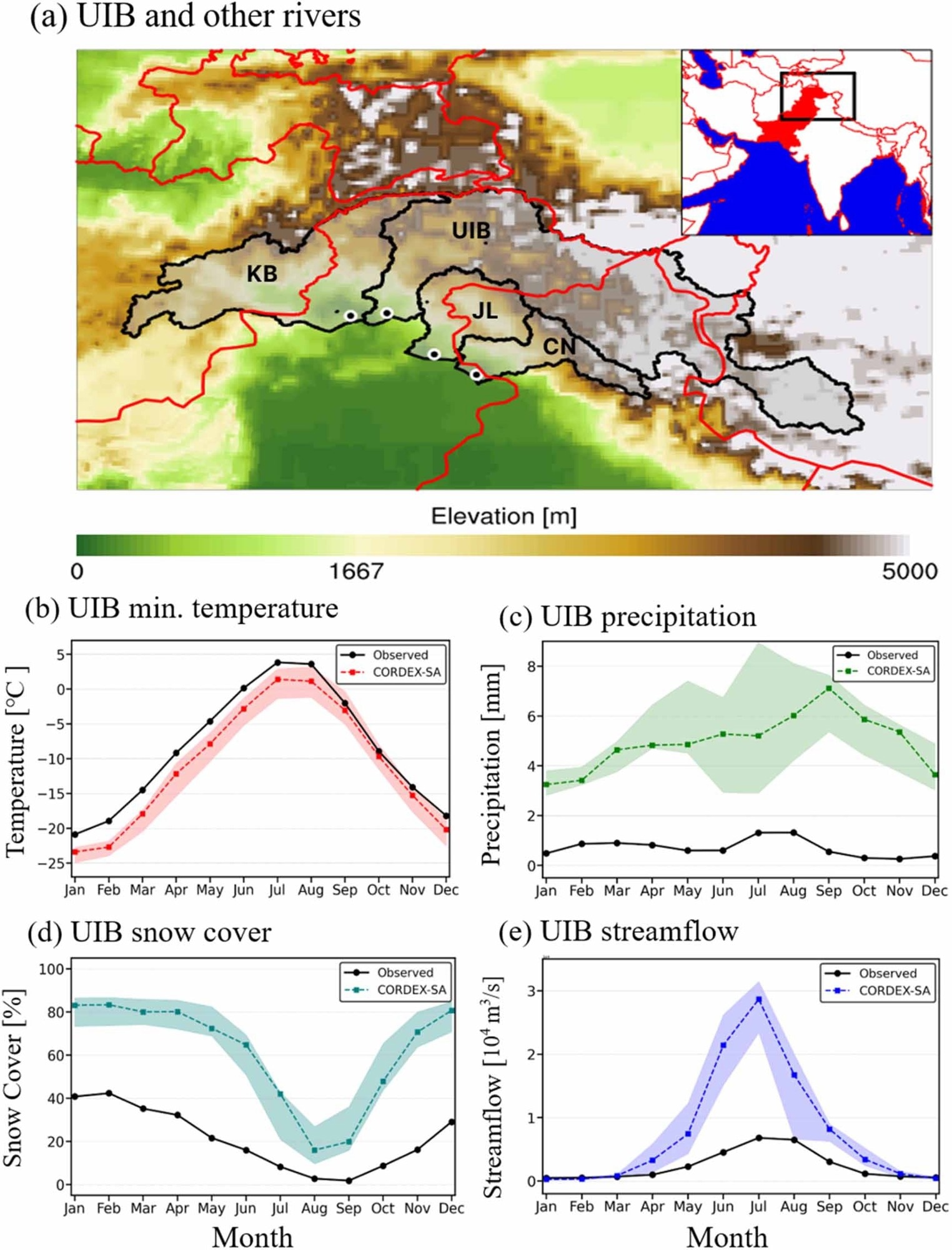
Study river basins and seasonality of the regional hydroclimatology of the Upper Indus River (UIB). (a) UIBs and other studied river basins (Kabul (KB), Jehlum (JL), and Chenab (CN)). The 1981–2010 climatologies of daily minimum temperature (b), precipitation (c), snow cover (d), and streamflow (e). In (a), black and red solid lines represent basin and country boundaries, respectively and black dots show geographical location of the corresponding gage station. The black solid line and colored dashed line in (b)–(e) indicate the climatology of the observational data and the average of the climatology from the five CORDEX-SA models, respectively. Shaded areas in (b)–(e) depict the range of the climatology from the five CORDEX-SA models.
A new study published in Environmental Research Letters and led by Professor Jonghun Kam's team at POSTECH (Pohang University of Science and Technology) has uncovered a concerning projection for Pakistan's future. Using multiple AI models to generate observation-constrained projections of record-event probabilities, the research predicts that the country will face unprecedented record-breaking high-flow (“flood-like”) and low-flow (“drought-like”) events, quantified by statistical return periods rather than a fixed periodic cycle. This increased likelihood of record events is linked to climate-change-driven intensification of extremes, particularly in vulnerable high-altitude regions where glaciers are melting.
Why Pakistan?
The team focused on Pakistan because its major rivers, such as the Indus, are the country's lifeline; however, climate change has made water resource management increasingly complex. As a "Global South" nation, Pakistan is especially vulnerable to climate change and lacks the economic and technological infrastructure to conduct extensive research.
AI Tackles Inaccurate Climate Models
To overcome these challenges, Professor Kam's team turned to artificial intelligence. Traditional climate models often struggle to accurately represent complex terrains, such as Pakistan's steep mountains and narrow valleys. They tend to underestimate changes in these areas or overestimate rainfall, which makes their predictions unreliable.
How the AI Approach Works
The researchers trained an ensemble of eight AI models by comparing past river flow data with actual observations, which improved the skill of projections for record-event probabilities and narrowed uncertainty bands. This AI-based approach proved to be more effective than traditional models in reproducing past extremes.
What Does the AI Forecast?
The analysis revealed a disturbing pattern. The Upper Indus shows record-breaking high- and low-flow events roughly every 15 years. The Chenab and Kabul exhibit more frequent high-flow record events, approximately every 11 years, while the Jehlum is more prone to low-flow record events, also roughly every 11 years. These are statistical return periods, not fixed cycles, and they vary depending on the emissions scenario. This projection is a clear call to action, urging the Pakistani government to adopt tailored water management strategies for each river basin, rather than relying on a one-size-fits-all approach. Professor Kam stated that this new AI technology will be crucial for producing reliable climate data not only for Pakistan but also for other climate-vulnerable and data-poor regions worldwide.
Research Collaboration and Support
This research was conducted by a team led by Professor Jonghun Kam from POSTECH's Division of Environmental Science and Engineering, in collaboration with doctoral student Hassan Raza, and Professor Dagang Wang's team from Sun Yat-sen University in China. The study was supported by the National Research Foundation of Korea's Individual Basic Research Program and the BK21 FOUR Program. Hassan Raza received support from the 'Global Korean Scholarship'. The authors note that projections are based on naturalized streamflow and do not account for reservoir operations or irrigation; the approach relies on long observational records.
Source:
- Pohang University of Science & Technology (POSTECH)
Journal reference:
 How Deep Learning Is Optimizing Biodiesel Feedstocks for a Greener Future