A pioneering study led by the University of Oxford in collaboration with international partners has applied AI for the first time to count the Great Wildebeest Migration from satellite images. Unexpectedly, the results showed fewer than 600,000 individual wildebeest—less than half the previous estimate of 1.3 million animals. The results have been published in the journal PNAS Nexus.
Lead researcher Dr Isla Duporge (Wildlife Conservation Research Unit, Oxford University at the time of the study, now Princeton University) said: "The field of wildlife conservation relies on having accurate data on wildlife population numbers. Combining earth observation satellite data with deep learning, this study has revolutionised our understanding of migratory wildebeest numbers, and could open the floodgates for surveying other species using this method."
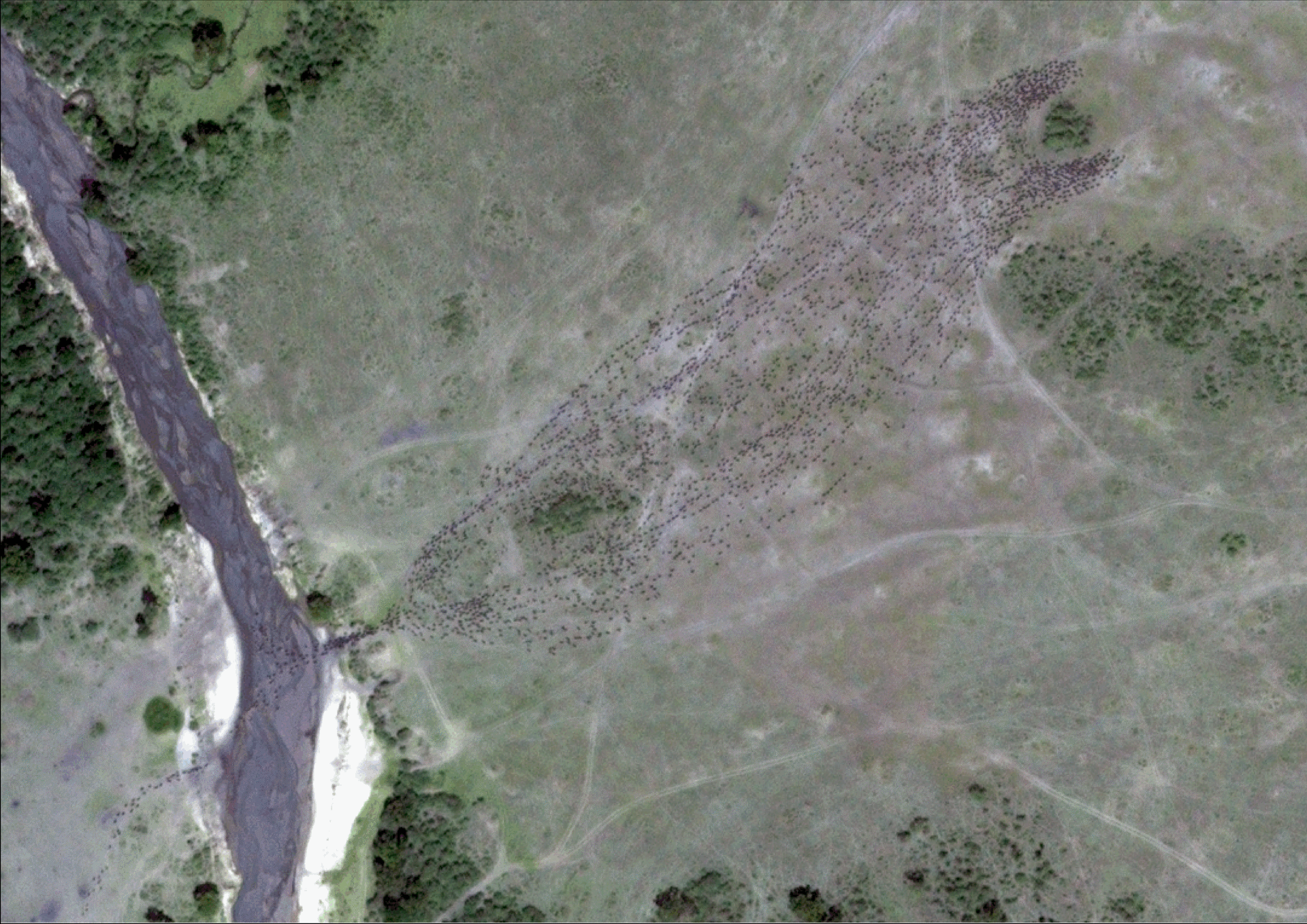
WorldView-3 satellite image showing individual wildebeest resolved at the pixel level. Figure created by Tiejun Wang
The Great Wildebeest Migration across the Serengeti-Mara is one of the world's greatest wildlife spectacles. The migration is crucial for the survival of vast numbers of iconic predators, including lions, crocodiles, and spotted hyenas. It also attracts visitors from across the world, generating vital tourism revenue for Kenya and Tanzania.
Up to now, population estimates of Serengeti-Mara migratory wildebeest have relied on manned aerial surveys. These involve flying aircraft along pre-determined straight lines and photographing herds below. Because this approach only directly surveys a small area at a time, statistical models are used to extrapolate densities across unsurveyed regions. This can introduce errors if the herds are unevenly distributed during the survey and move between survey transects.
Satellite surveys offer a compelling alternative. These allow for much wider coverage (up to hundreds of thousands of square kilometres in a single photograph), reducing the chance of double-counting and eliminating the need for extrapolative projections. Additionally, satellite-based surveys do not disturb wildlife and are much safer than manned aircraft. However, the sheer volume of data makes it impractical to count wildebeest from these images manually.
In the new study, a team led by Dr. Isla Duporge, in collaboration with Professor David Macdonald at Oxford's Wildlife Conservation Research Unit, trained two deep-learning models (U-Net and YOLOv8) to identify wildebeest using a dataset of 70,417 manually labeled wildebeest. Both models performed strongly, achieving F1 scores (a measure of accuracy) up to 0.83.*
The models were then applied to over 4,000 km² of high-resolution satellite imagery of the Masai Mara National Reserve, which spans Tanzania and Kenya. These images were captured from August 2022 to 2023 by Maxar Technologies' Worldview-2 and 3 satellites, located between 617 and 770 kilometres above the Earth's surface.
The results from the two AI models were highly similar, ranging from 324,202 to 337,926 in 2022 and from 502,917 to 533,137 in 2023. This results in a shortfall of at least 700,000 wildebeest compared to the previous estimate of 1.3 million, which stems from aerial surveys—a figure that has remained essentially unchanged since the 1970s.
According to the researchers, the new numbers may even be a slight overestimate. At current satellite resolutions (30–60 cm per pixel), individual wildebeest appear as 6–12 pixel shapes, meaning that the models cannot distinguish wildebeest from similar-sized animals such as zebras and eland.
Dr Isla Duporge said, "The sheer difference between traditional estimates and our new results raises questions about where the 'missing' wildebeest might be. Based on data from GPS tracking surveys, we are confident that most of the herd was contained within the surveyed area. And whilst some individuals may have been obscured by tree cover, it seems unlikely that such a large number—on the order of half a million—would have been concealed in this way."
According to the researchers, the lower counts do not necessarily mean that wildebeest populations have collapsed in recent years, as they may have adjusted their migration routes in response to environmental changes. Nevertheless, wildebeest face significant pressures. Habitat fragmentation, driven by agricultural expansion, infrastructure development, and fencing, has reduced the available space for wildebeest migration routes, while climate change is altering seasonal rainfall patterns, affecting the abundance of prime grazing areas. Accurate population estimates are therefore crucial to inform targeted conservation efforts.
The study builds on the research team's previous success in training an AI model to recognise elephants from satellite data. This is the first time, however, that this approach has been used to conduct a census of individual mammals in a large, distributed population, rather than isolated groups. According to the researchers, the technique could be applied to many other herd mammals, including reindeer, zebra, and camels. The team is currently developing a similar method to detect and count African rhinos.
Study co-author Professor David Macdonald (founder of the Wildlife Conservation Research Unit, Oxford University) said: "The most basic fact to know as a foundation for conserving any species is how many of them there are. The technological breakthrough of our study—satellite-based wildlife monitoring, powered by AI—potentially revolutionises the answer for wildebeest, besides opening up incredible possibilities for monitoring other large species."
The researchers have made the code for their model available at github.com/sat-wildlife/wildebeest
* F1 scores range from 0 to 1, and are a measure of accuracy. A score of 1.0 means the model has perfect precision (correctly identifying each object) and recall (finding all the objects). An F1 score greater than 0.8 is generally considered excellent for wildlife applications.
Besides the University of Oxford, the study also involved researchers from Princeton University, the University of Hong Kong, the University of Twente, the University of British Columbia, the Army Research Office (Durham, NC), and Sun Yat-sen University.
Source:
Journal reference:
- Duporge, I., Wu, Z., Xu, Z., Gong, P., Rubenstein, D., Macdonald, D. W., Sinclair, A. R., Levin, S., Lee, S. J., & Wang, T. (2025). AI-based satellite survey offers independent assessment of migratory wildebeest numbers in the Serengeti. PNAS Nexus, 4(9). DOI: 10.1093/pnasnexus/pgaf264, https://academic.oup.com/pnasnexus/article/4/9/pgaf264/8249339
 New AI Framework LLRL Accurately Detects Plant Disease Severity for Smarter Farming